- Sections :
- Crime & Public Safety
- Restaurants & Food
- Sports
- More
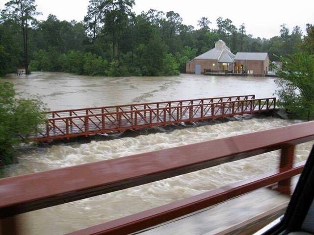
THE WOODLANDS, Texas -- Area flooding conditions continue to worsen as Tropical Storm Harvey stalls over the Texas coast and brings moisture from the Gulf over our area.
Most of Montgomery County has seen more than 13 inches of rainfall over the last 24 hours. We can expect to see an additional 15-25 inches from Sunday to Friday.
Current river forecast:
The West Fork of the San Jacinto near Conroe is currently in minor flood stage at
116.84 ft. and is forecast to crest Tuesday afternoon in major flood stage at 123.8
ft.
The East Fork of the San Jacinto near New Caney is currently in moderate flood
stage at 68.05 ft. and is forecast to crest Wednesday night in major flood stage at
73.2 ft.
Spring Creek near Spring is currently in major flood stage at 101.6 ft. and is
forecast to crest late tomorrow tonight in major flood stage at 112.4 ft.
Spring Creek at Tomball is in minor flood stage at 164.67 ft. and is forecast to crest
tonight in major flood stage at 166.5 ft.
Peach Creek near Splendora is currently in major flood stage at 23.69 ft. and is
forecast to crest tomorrow morning in major flood stage at 25.7 ft.
Caney Creek near Splendora is currently at 22.62 feet and is forecast to crest
tomorrow morning in major flood stage at 24.6ft.
The West Fork of the San Jacinto near Porter is currently at minor flood stage at
80.37 feet and is forecast to crest Tuesday night in major flood stage at 94.1t.
We are currently running out of high water barricades. We are working to get more, however,
motorists should use extreme caution when driving as some flooded or damaged roads may not
be barricaded until we can secure more barricades. Flowing water on roadways can easily sweep
a vehicle off the road. If you can stay at home, please do, do not drive unless you absolutely must.
Please do not go out sightseeing. Turn around Don’t Drown.
If you are displaced by the flooding waters, there are four shelter locations open:
St. Simon and Jude
26777 Glen Loch Road
Spring, TX 77381
Bull Sallas Park
21679 McCleskey Road
New Caney, TX 77357
Magnolia High School
14350 FM 1488,
Magnolia, TX 77354
Under and Over Fellowship
600 South Frasier Street
Conroe TX 77301
Wildwood Methodist is CLOSED
School Closures for Monday August 28 and Tuesday August 29:
Conroe ISD
Montgomery ISD
New Caney ISD
Magnolia ISD
Willis ISD
Splendora ISD is closed through September 5
For help and information on preparing for disasters, download our new preparedness
app ReadyMCTX to your mobile device. Now is the time to make sure preparations are
in order and check your emergency kits.
To receive emergency alerts to your phone or email from Montgomery County Office of Emergency Management, register at https://www.smart911.com/. When you are creating
your profile, you must check the box next to Share my Smart911 Profile with TX-
Montgomery-County-911 to support emergency preparedness.
Stay informed and monitor conditions for Montgomery County and the surrounding area
on the Office of Homeland Security and Emergency Management website
www.mctxoem.org, Facebook, or twitter, NOAA Weather Radio, KStar 99.7FM.