- Sections :
- Crime & Public Safety
- Restaurants & Food
- Sports
- More
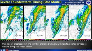
THE WOODLANDS, TX -- It is looking more likely that a squall line of thunderstorms will develop in central Texas this evening and then move across SE Texas tonight. The Montgomery County area is still at an enhanced risk for severe weather. The primary risks will be damaging wind gusts from the squall line and embedded tornadoes. Hail is another risk but more to the NW of the area as storms first develop. Overall timing has not changed much with the line moving into the College Station around 8-11PM, Houston area around midnight and then off the coast to the east after 2AM. The possibility of significant severe weather has shifted to the moderate risk area to the north. No flash flooding is expected at this time.
• Thunderstorms, potentially severe, are expected
• The window for severe weather will be 1-2 hours
• Damaging winds and tornadoes are the main threats
• Large hail is also possible, but more likely to impact farther north of Montgomery County
• Not every location will see storm damage, but pockets of stronger winds (60+mph) and tornadoes, power outages, downed trees, structural damage would be expected.
To receive emergency alerts to your phone or email from Montgomery County Office of Emergency Management, register at http://www.mc911.org/page/ecd.AlertMCTX. When you are creating your profile, you must check the box next to Share my Smart911 Profile with TX-Montgomery-County-911 to support emergency preparedness.
Stay informed and monitor conditions for Montgomery County and the surrounding area on the Office of Homeland Security and Emergency Management website www.mctxoem.org, Facebook, or twitter, NOAA Weather Radio, KStar 99.7FM.
The Montgomery County Office of Homeland Security and Emergency Management will continue to monitor the weather situation and provide updates as we receive them.