- Sections :
- Crime & Public Safety
- Restaurants & Food
- Sports
- More
THE WOODLANDS, TX -- September 13, 4:30 update: Just wrapped up another National Weather Service briefing.
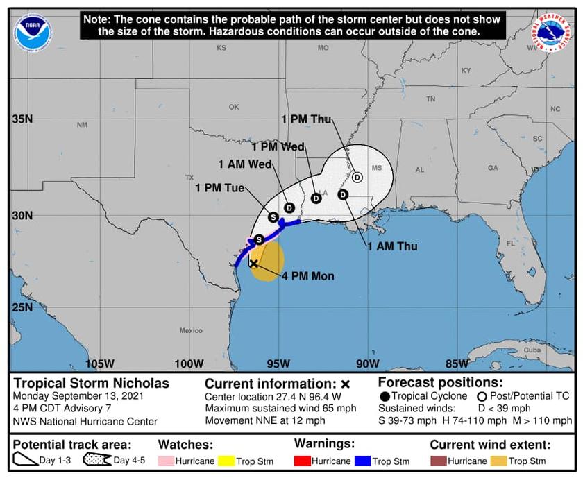
TS Nicholas has increased in intensity slightly but remains a tropical storm. The forecast track has shifted more east again this is good news for us when it comes to total rainfall expected.
The rainfall accumulation forecast has decreased with the shift in the forecast track. Heaviest rain will stay closest to the coast and most of Montgomery County is expected to see 2-4 inches throughout the county with pockets on the far southeast side as high as 6 inches. This is substantially lower than what was originally forecasted yesterday and overnight.
So far today we have not seen more than a half inch of rain across the county. Lake Conroe remains 18 inches below normal.
Overnight more rain bands will move through the county and we will see some periods of heavy rain but nothing major beyond typical flash flooding along low lying roads during the rain. Remember, turn around don’t drown.
Next update at 10pm. Will provide any details and updates as they come.
September 13-11 am update: Just wrapped up a national weather service briefing. The track has shift slightly east for TS Nicholas. This shift is good news for us as rain accumulations should decrease if this shift holds.
Since we are still expecting 5-7 inches through now and Thursday please remember to Turn around don’t drown.
Heaviest rain for us will be overnight tonight and tomorrow. Rain predictions vary for the county and the weather services stressed the accumulation amounts are changing with the shifting of this storm. Updated graphics and forecast will be forthcoming.
The center of circulation is expect to go over Montgomery County sometime tomorrow. We still don’t expect wind to be a factor by the time the storm gets over us. Rain will be our main threat.
Depending on how the center tracks rain will be highest southeast of center and lowest northwest of center. This is seen in the rain accumulation slide where the south east portion of the county will see the highest amounts and the northwest side will see the lowest. Of course anything can change and forecast with Nicholas has changed a lot over the last 12 hours.
Landfall as a strong Tropical Storm tonight near Matagorda Bay moving northeast from there. Forecasters caution this storm could strengthen into a low category 1 still.
As more details become available I will pass it along.
All of our county agencies and resources are standing by and prepared to respond.