- Sections :
- Crime & Public Safety
- Restaurants & Food
- Sports
- More
Categories

THE WOODLANDS, TX – As our Monday progresses, we’ll continue to handle off-and-on-again thunderstorms, which will remain pretty isolated throughout The Woodlands area until tomorrow evening or later. One particular surge may hit us around quitting time, so be careful on the roads. Cloud coverage, winds, humidity, and pressure will all remain high for a while. We have, however, already hit our high of 89 – which felt like 93 with the heat index – and are rapidly seeing temperatures drop down until they settle in the mid 60s overnight.
The chances of Tuesday thunderstorms will be greatest in the evening, as the peaked-out pressure starts to drop. The Tuesday high will only be around 85, bumped up a couple of degrees due to the humidity, and right around the time the mercury turns in the other direction, the chances of thunderstorms will spike.
On Wednesday, the chance of precipitation will be greatly diminished, but the clouds will nonetheless increase, resulting in officially partly cloudy skies. Some warmth will be trapped beneath them, bringing our temperature to nearly 90. Fortunately, the overnight lows will again by in the 60s for nighttime relief from the heat and humidity.
It will be more of the same on Thursday; a high of around 90 with moderate winds and mostly sunny skies, this time with a next-to-nothing chance of thunder and lightning. It’ll be the first night this week, however, where the low won’t quite make it down into the 60s.
Friday will be the warmest day yet this week, getting all the way up to 95 for the high and an additional humidity factor that will make it feel like 99. Wear the SPF outdoors because there will be far fewer clouds, and this day marks the onset of a warming trend that’ll get a lot more warmer soon enough…
Stay tuned on Friday as we bring you Woodlands Weekend Weather.
Not too hot, not too dry, not too wet this week
The chances of Tuesday thunderstorms will be greatest in the evening, as the peaked-out pressure starts to drop. The Tuesday high will only be around 85, bumped up a couple of degrees due to the humidity, and right around the time the mercury turns in the other direction, the chances of thunderstorms will spike.
On Wednesday, the chance of precipitation will be greatly diminished, but the clouds will nonetheless increase, resulting in officially partly cloudy skies. Some warmth will be trapped beneath them, bringing our temperature to nearly 90. Fortunately, the overnight lows will again by in the 60s for nighttime relief from the heat and humidity.
It will be more of the same on Thursday; a high of around 90 with moderate winds and mostly sunny skies, this time with a next-to-nothing chance of thunder and lightning. It’ll be the first night this week, however, where the low won’t quite make it down into the 60s.
Friday will be the warmest day yet this week, getting all the way up to 95 for the high and an additional humidity factor that will make it feel like 99. Wear the SPF outdoors because there will be far fewer clouds, and this day marks the onset of a warming trend that’ll get a lot more warmer soon enough…
Stay tuned on Friday as we bring you Woodlands Weekend Weather.

Comments •

More From: Woodlands Online (577)

Ready to cast your ballot? Only one week left until voting begins for the 2026 ‘Best of The Woodlands’ Awards

Time is short for local businesses to register for the 2026 ‘Best of The Woodlands’ Awards

Register Now: Woodlands Online to host free AI Symposium this Wednesday

Woodlands Online celebrates ‘Best of The Woodlands’ winners at Ale & Ivy party
Code Test Do Not Post

Top Things to Do This Week in The Woodlands – March 24 - 30, 2025

Top Things to Do This Week in The Woodlands – March 3 - 9, 2025

Woodlands Online announces the winners for the 2025 ‘Best of The Woodlands’ Awards

Top Things to Do This Week in The Woodlands – February 24 - March 2, 2025

Top Things to Do This Week in The Woodlands – February 17 - 23, 2025

14 fun things to do in The Woodlands for Valentine’s Day

Top Things to Do This Week in The Woodlands – February 10 - 16, 2025
Related News: Weather

Monday's Weather Update: Normal operations resume on Tuesday

Saturday's Weather Update: The Woodlands Express Bus will not operate on Monday
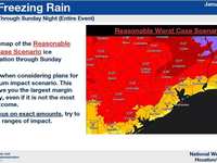
Montgomery County Issues Winter Weather Alert as Freezing Conditions Intensify

Red Cross offers tips to prevent pipes from freezing and ways to thaw them if frozen
