- Sections :
- Crime & Public Safety
- Restaurants & Food
- Sports
- More
Categories
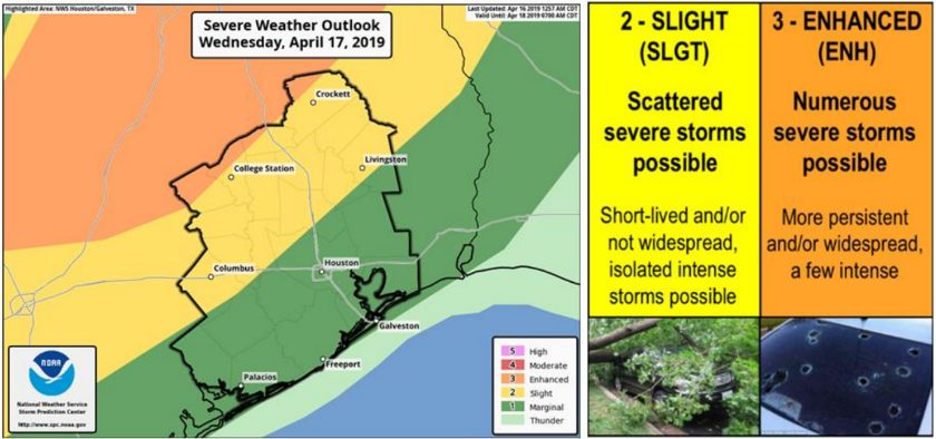
MONTGOMERY COUNTY, TX - Montgomery County could experience scattered severe storms on Wednesday evening or early Thursday morning. Timing of storms is projected to be between 7 PM and 7 AM. If these storms develop we can expect isolated areas to receive between one and two inches of rain. These storms may produce hail and wind gusts as high as 20 mph. The weather patterns could also be favorable for tornado activity, heed all National Weather Service (NWS) warnings and seek shelter if alerted to do so.
From the National Weather Service, the eastern approach of a western upper trough will place our region in a more favorable jet region for the development and sustainment of strong to severe thunderstorms. There will be a brief window of opportunity for the evolution of strong storm cells that could form into a more organized line along their eastward advancement early Thursday morning.
For help and information on preparing for disasters, download our new preparedness app ReadyMCTX to your mobile device. Now is the time to prepare. To receive emergency alerts to your phone or email from Montgomery County Office of Emergency Management, register at http://www.mc911.org/page/ecd.AlertMCTX. When you are creating your profile, you must check the box next to Share my Smart911 Profile with TX-Montgomery-County-
911 to support emergency preparedness.
Stay informed and monitor conditions for Montgomery County and the surrounding area on the Office of Homeland Security and Emergency Management website www.mctxoem.org, Facebook, or twitter @mcoem, NOAA Weather Radio, K-STAR 99.7FM.
Comments •

More From: (16518)
Texas Workforce Commission Reemployment Program receives national award

LSGCD is offering discounted rainwater harvesting kits for Rain for Tomorrow Conservation Initiative

Texas voters to decide on a combined 23 non-binding advisory questions in the March 3 primaries

Bob Harvey responds to 'false online claims,' reaffirms commitment to Precinct 2 voters

Shot Through the Heart - The Crooks to Blame. Crooks Give Love a Bad Name.

Nick’s Local Eats Celebrates 2025 Year End Awards

Texas Workforce Commission Welcomes New Executive Director Steve Pier

Conroe EDC Praises Hospitality, Generosity of Joe's Italian Restaurant's Holiday Meal Distribution

For the 70th year, NORAD will track Santa for your kiddos this Christmas Eve

Building Confidence Through Structure

Texas Pink Playbook Hosts Sold-Out Elvis Presley–Themed Event as It Emerges as One of Texas’ Fastest

A Lifetime of Accountability: Offender to Serve 75-Year Day-for-Day Sentence
Related News: Woodlands Area

Market Street Hosts Influencer Consignment Sale Saturday, March 28

Main Street Theater and The Pavilion Present The True Story of the Three Little Pigs with Two Free Performances

Spring at City Place: Easter Celebration, Vinyl DJs & Mamma Mia! Movie Night

Top Things to Do This Week in The Woodlands – March 16 - 22, 2026
