- Sections :
- Crime & Public Safety
- Restaurants & Food
- Sports
- More
Categories
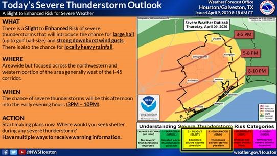
MONTGOMERY COUNTY, TX -- A cold front will be moving into the College Station area around mid-afternoon today and will cause storms to develop. A very unstable air mass will be in place across Southeast with afternoon temperatures in the mid-80s to lower 90s and humid! This will fuel strong to severe thunderstorms with the primary threat being large hail and secondarily strong damaging winds. Our area is expected to have the rainfall rate of 2-3'/hour. These storms should spread east and southeast into the Conroe area between 5 and 8 pm then to the coast early evening. Storms may also redevelop with a cluster as an area of low pressure develops along the front, this could aggravate the heavy rain situation.
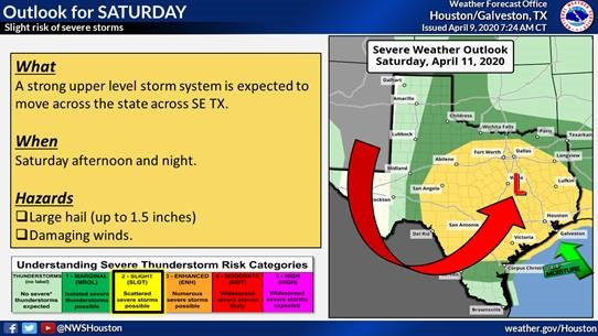
Another system should bring another widespread round of thunderstorms Saturday afternoon through mid-morning Sunday. Again a threat of severe weather and the Storm Prediction Center has placed the area in a slight risk. Hail and damaging winds are the threats. A persistent moderate to strong easterly wind along the coast should also raise tide levels and strengthen rip currents Friday through Saturday.
To receive emergency alerts to your phone or email from Montgomery County Office of Emergency Management, register at http://www.mc911.org/page/ecd.AlertMCTX. When you are creating your profile, you must check the box next to Share my Smart911 Profile with TX-Montgomery-County-911 to support emergency preparedness.
Stay informed and monitor conditions for Montgomery County and the surrounding area on the Office of Homeland Security and Emergency Management website www.mctxoem.org, Facebook, or twitter, NOAA Weather Radio, KStar 99.7FM.
The Montgomery County Office of Homeland Security and Emergency Management will continue to monitor the weather situation and provide updates as we receive them.
Photos
Comments •

More From: (16518)
Texas Workforce Commission Reemployment Program receives national award

LSGCD is offering discounted rainwater harvesting kits for Rain for Tomorrow Conservation Initiative
Texas voters to decide on a combined 23 non-binding advisory questions in the March 3 primaries

Bob Harvey responds to 'false online claims,' reaffirms commitment to Precinct 2 voters

Shot Through the Heart - The Crooks to Blame. Crooks Give Love a Bad Name.

Nick’s Local Eats Celebrates 2025 Year End Awards

Texas Workforce Commission Welcomes New Executive Director Steve Pier

Conroe EDC Praises Hospitality, Generosity of Joe's Italian Restaurant's Holiday Meal Distribution

For the 70th year, NORAD will track Santa for your kiddos this Christmas Eve

Building Confidence Through Structure

Texas Pink Playbook Hosts Sold-Out Elvis Presley–Themed Event as It Emerges as One of Texas’ Fastest

A Lifetime of Accountability: Offender to Serve 75-Year Day-for-Day Sentence
Related News: Woodlands Area

Market Street Hosts Influencer Consignment Sale Saturday, March 28

Main Street Theater and The Pavilion Present The True Story of the Three Little Pigs with Two Free Performances

Spring at City Place: Easter Celebration, Vinyl DJs & Mamma Mia! Movie Night

Top Things to Do This Week in The Woodlands – March 16 - 22, 2026
