- Sections :
- Crime & Public Safety
- Restaurants & Food
- Sports
- More
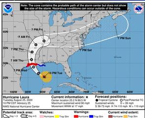
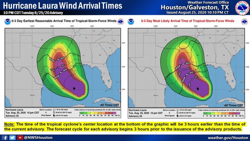
THE WOODLANDS, TX -- No major changes to the forecast track. Hurricane Laura now has maximum sustained winds of 90 mph. Laura is expected to be a Major Hurricane at landfall near the TX/LA border.
Keep in mind that impacts can occur well away from the center of the storm. Residents along the coast and across the greater Houston area should prepare the possibility of strong winds, heavy rain and dangerous storm surge. Now is the time to make your final preparations!
Next advisory will be at 1 AM CDT (August 26)
Highlights
Significant strengthening is forecast and Laura is expected to be a Major hurricane at landfall near the TX/LA border.
A Hurricane Warning is in effect between San Luis Pass, TX and the mouth of the Mississippi River.
A Tropical Storm Warning is in effect between Sargent, TX and San Luis Pass, TX and from the mouth of the Mississippi River to Intracoastal City, LA.
Max Sustained Wind 90 (Category 1)
Movement: WNW at 17 mph
Location: 430 miles southeast of Galveston, TX
Pressure: 978 MB
Coordinates: 25.2 N 89.5 W