- Sections :
- Crime & Public Safety
- Restaurants & Food
- Sports
- More

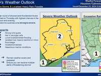
THE WOODLANDS, TX - Kevin Brady sent out the following weather alert earlier today.
*WHAT...A low pressure system will bring a period of dangerous and potentially destructive freezing rain across the region into the early afternoon. Ice amounts are expected to range from a trace to a tenth of an inch along and north of the Highway 59 corridor with higher amounts in excess of one quarter inch north of a line from Columbus to Conroe to Livingston. There is the potential for this magnitude of ice to be very destructive, with the potential to create additional power outages and vegetation and tree damage. At 1000 AM, highway 105 west and FM
1486 in Montgomery County were iced over.
Temperatures will fall back below freezing tonight as colder air spreads south in the wake of a cold front. Any residual liquid water on roads or sidewalks will quickly refreeze. Some light snow or sleet may also fall Thursday morning in the wake of the front though accumulation amounts should be very light on the order of a trace.
* WHERE...Inland areas of Southeast Texas.
* WHEN...Through Thursday morning.
* IMPACTS...Icy conditions will worsen quickly across the region this morning. The power outages already present in many locations could worsen. Even though some areas may thaw out briefly, the potential for refreeze will be high tonight with another cold front bringing subfreezing temperatures back across the region.