- Categories :
- More
Flood Watch issued October 24 at 12:59PM CDT until October 26 at 5:00AM CDT

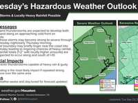
Flooding caused by excessive rainfall is possible. * WHERE...A portion of southeast Texas, including the following areas, Austin, Bolivar Peninsula, Brazoria Islands, Brazos, Burleson, Chambers, Coastal Brazoria, Coastal Galveston, Coastal Harris, Coastal Matagorda, Colorado, Fort Bend, Galveston Island, Grimes, Houston, Inland Brazoria, Inland Galveston, Inland Harris, Inland Matagorda, Madison, Matagorda Islands, Montgomery, Northern Liberty, Polk, San Jacinto, Southern Liberty, Trinity, Walker, Waller, Washington and Wharton. * WHEN...From late tonight through early Sunday morning. * IMPACTS...Excessive runoff may result in flooding of rivers, creeks, streams, and other low-lying and flood-prone locations. Flooding may occur in poor drainage and urban areas. * ADDITIONAL DETAILS... - Although soils are dry ahead of this heavy rainfall event, there is enough support in guidance for high rainfall rates to lead to some instances of flash flooding. There will be two rounds of heavy rainfall with the first one being late Friday night into Saturday morning and Saturday evening into early Sunday morning. Widespread rainfall totals of 2-4" with isolated higher amounts up to 4-6". Rainfall rates in the strongest storms could exceed 2-3" per hour, which could lead to flash flooding if these rainfall rates occur for a prolonged period of time. There is expected to be a lull in the activity late Saturday morning into the afternoon which will allow for drainage, so the flood threat is primarily driven by the potential for high rainfall rates. - http://www.weather.gov/safety/flood


