- Categories :
- More
Categories

The Woodlands Information Station
Weather Category
Sort By:

Posted Thu, Jul 03, 2025
At 228 PM CDT, Doppler radar was tracking a strong thunderstorm near Pinehurst, moving north at 20 mph. HAZARD...Wind gusts up to 40 mph

Posted Wed, Jul 02, 2025
Amazingly, we seem to be in a bit of a sweet spot for this year’s Independence Day celebrations – not too hot, not too bright, not too dry. Here’s a breakdown for the long weekend and how it might affect your celebratory plans.
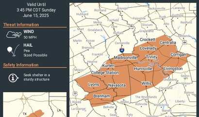
Posted Sun, Jun 15, 2025
At 315 PM CDT, Doppler radar was tracking a strong thunderstorm over Spring, moving east at 10 mph. HAZARD...Wind gusts up to 50 mph

Posted Fri, Jun 13, 2025
SVRHGX The National Weather Service in League City has issued a * Severe Thunderstorm Warning for... South central Montgomery County in southeastern Texas..

Posted Fri, Jun 13, 2025
At 631 PM CDT, Doppler radar was tracking a strong thunderstorm near Pinehurst, moving east at 10 mph. HAZARD...Wind gusts up to 40 mph and pea size hail.

Posted Fri, Jun 13, 2025
At 308 PM CDT, Doppler radar was tracking a strong thunderstorm near Spring, moving east at 25 mph. HAZARD...Wind gusts up to 40 mph and pea size hail.

Posted Thu, Jun 12, 2025
At 5:47 this morning the National Weather Service issued a Flood Watch through 7 o'clock this evening.
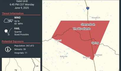
Posted Mon, Jun 09, 2025
At 623 PM CDT, a severe thunderstorm was located over Oak Ridge North, or near Spring, moving east at 10 mph. HAZARD...60 mph wind gusts and quarter size hail.
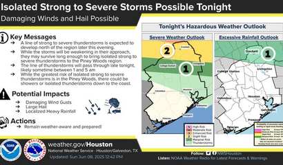
Posted Sun, Jun 08, 2025
Late tonight and into the early morning hours, our area could see a line of thunderstorms moving through—some of which could be strong to severe

Posted Wed, Jun 04, 2025
We could be minutes away from a brief thundershower, where there will be more noise than anything else, but should any rain actually fall from the dark clouds, it will be light and brief.

Posted Mon, Jun 02, 2025
June 1st marks the official start of the 2025 Atlantic hurricane season—and if history has taught us anything, it’s that preparation is the key to safety.

Posted Sun, Jun 01, 2025
Severe Thunderstorm Watch 352 remains valid until 10 PM CDT this evening for the following areas In Texas this watch includes 12 counties In southeast Texas Austin

Posted Sun, Jun 01, 2025
SVRHGX The National Weather Service in League City has issued a * Severe Thunderstorm Warning for... Southeastern Montgomery County in southeastern Texas...

Posted Wed, May 28, 2025
At 1001 AM CDT, Doppler radar was tracking a cluster of strong thunderstorms near Todd Mission, or 8 miles northeast of Prairie View, moving northeast at 20 mph. HAZARD

Posted Mon, May 26, 2025
The National Weather Service has issued Severe Thunderstorm Watch 335 in effect until 5 AM CDT Tuesday for the following areas In Texas this watch includes
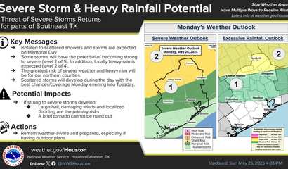
Posted Mon, May 26, 2025
Local authorities are urging residents and visitors to stay alert today as two rounds of storm activity are expected to move through the area.

Posted Tue, May 13, 2025
Believe it or not, yesterday we were six degrees below average for our high temperature and only eight degrees away from a record low. You wouldn't know it today, as a heat wave has moved in and decided to stay for the next week or so.

Posted Tue, May 06, 2025
Tornado Watch 231, previously in effect until 6 PM CDT this evening, is now in effect until 8 PM CDT this evening for the following areas In Texas this watch includes

Posted Tue, May 06, 2025
Tornado Watch 231, previously in effect until 4 PM CDT this afternoon, is now in effect until 6 PM CDT this evening for the following areas In Texas
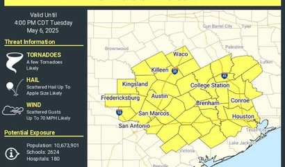
Posted Tue, May 06, 2025
The National Weather Service has issued Tornado Watch 231 in effect until 4 PM CDT this afternoon for the following areas In Texas this watch includes 16 counties
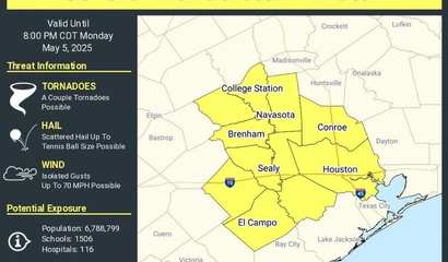
Posted Mon, May 05, 2025
The National Weather Service has issued Severe Thunderstorm Watch 225 in effect until 8 PM CDT this evening for the following areas In Texas this watch includes 11 counties

Posted Mon, May 05, 2025
Our work week starts off nice and cool; in fact, we won't even get over 80 degrees today. Right around the time when the afternoon heat typically kicks in, we'll get some cloud cover, and many of those clouds will be filled with precipitation re...
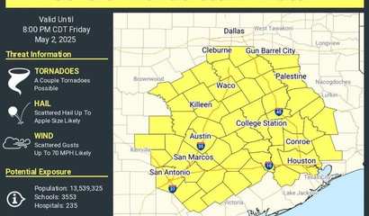
Posted Fri, May 02, 2025
THE NATIONAL WEATHER SERVICE HAS ISSUED SEVERE THUNDERSTORM WATCH 212 IN EFFECT UNTIL 8 PM CDT THIS EVENING FOR THE FOLLOWING AREAS IN TEXAS

Posted Fri, May 02, 2025
We're about to get hit with some significant storms -- nothing near approaching flood levels, but still about an inch to be dropped in only a couple of hours. Around 4 o'clock this afternoon, the skies should clear up, but we'll effectively be s...
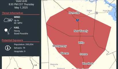
Posted Thu, May 01, 2025
The National Weather Service in League City has issued a * Severe Thunderstorm Warning for... Central Montgomery County in southeastern Texas... Southwestern San Jacinto County in southeastern Texas... Southern Walker County in southeastern Texas

Posted Thu, May 01, 2025
The National Weather Service has extended Severe Thunderstorm Watch 204 to include the following areas until 9 PM CDT this evening

Posted Wed, Apr 23, 2025
At 1025 AM CDT, Doppler radar was tracking a strong thunderstorm near Lake Conroe Dam, or 8 miles northeast of Pinehurst, moving north at 25 mph
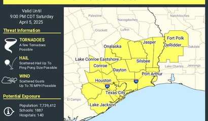
Posted Sat, Apr 05, 2025
The National Weather Service has issued Tornado Watch 123 in effect until 9 PM CDT this evening for the following areas In Texas this watch includes 9 counties In southeast

Posted Mon, Mar 24, 2025
Though wild thunderstorms blitzed through the area in the middle of last night (waking up many of us, including the Woodlands Online Weather Team) and today has been warm and dry, we have to let you know that the wet stuff ain’t done for, not by...
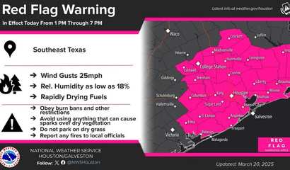
Posted Thu, Mar 20, 2025
The National Weather Service (NWS) in Houston/Galveston has issued a Red Flag Warning for Southeast Texas due to low relative humidity, breezy winds,

Posted Sat, Mar 15, 2025
Elevated to Critical Fire Weather Conditions Expected Today... Elevated to critical fire weather conditions are expected across the large majority of Southeast Texas.

Posted Thu, Mar 13, 2025
A Fire Weather Watch was issued March 13 at 2:58PM CDT until March 15 at 9:00PM CDT by NWS Houston/Galveston TX
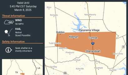
Posted Sat, Mar 08, 2025
At 521 PM CST, Doppler radar was tracking a strong thunderstorm near Magnolia, or 7 miles north of Pinehurst, moving east at 35 mph. HAZARD..

Posted Fri, Mar 07, 2025
Welcome to The Woodlands, where it gets up to 80 degrees on a Friday and won’t be able to crawl out of the 50s a mere 48 hours later. We’ll throw in some rain for good measure to keep the weekend interesting.
Posted Tue, Mar 04, 2025
At 445 PM CST, satellite imagery and observations showed a long dust cloud along a line extending from 6 miles east of Grapeland to near Millican to near Rosanky.
Posted Tue, Mar 04, 2025
SVRHGX The National Weather Service in League City has issued a * Severe Thunderstorm Warning for... East central Trinity County in southeastern Texas.
Posted Tue, Mar 04, 2025
A Wind Advisory has been issued by the National Weather Service. South winds 20 - 30 mph becoming west late this morning and afternoon, with gusts as high as 45 mph possible. Gusty winds will blow around unsecured objects. Tree limbs coule be bl...

Posted Fri, Feb 28, 2025
Believe it or not, we’ll be in March by the time this weekend ends, and a few short weeks after that it will officially be spring. This weekend, however, the thermometer couldn’t wait for the official calendar page-turn. Our weekend will be mode...

Posted Tue, Feb 18, 2025
At 552 PM CST, Doppler radar was tracking a strong thunderstorm over Humble, moving northeast at 30 mph. HAZARD...Pea size hail. SOURCE

Posted Tue, Feb 18, 2025
AlertSense has issued an Extreme Cold Watch. Dangerously cold wind chills with as low as 16 degrees is possible for Montgomery and Inland Harris Counties. This watch will be in effect from late Wednesday night through Thursday morning.

Posted Wed, Jan 22, 2025
According to Montgomery County Judge Mark Keough's official social media, roadways around The Woodlands are clear and open with the following exceptions:

Posted Tue, Jan 21, 2025
Extreme Cold Warning issued January 21 at 9:03PM CST until January 22 at 9:00AM CST
Posted Tue, Jan 21, 2025
Tonight's Forecast:
• Expect another cold night with a hard freeze.
• Temperatures will plunge to 19°F with wind chills below 10°F.
Posted Mon, Jan 20, 2025
Tonight- Road conditions are expected to be dangerous during this winter event. Please avoid driving unless absolutely necessary.
Posted Sun, Jan 19, 2025
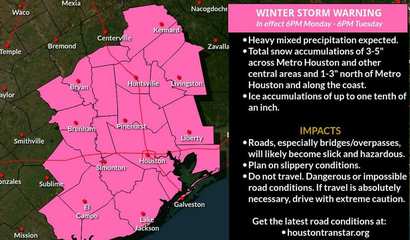
WHAT...Heavy mixed precipitation possible. Total snow accumulations of 3-5 inches across Metro Houston and other central areas.

Posted Sun, Jan 19, 2025
* WHAT...For the Cold Weather Advisory, very cold wind chills as low as 15. For the Extreme Cold Watch, dangerously cold wind chills as low as 10 possible. *
Posted Sat, Jan 18, 2025
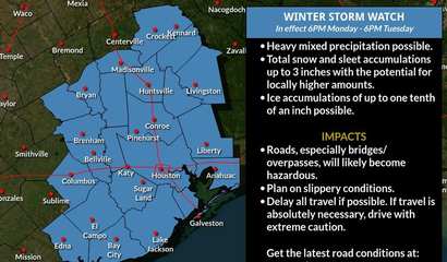
Heavy mixed precipitation possible. Total snow and sleet accumulations up to 3 inches with the potential for locally higher amounts.
Posted Fri, Jan 17, 2025
The U.S. National Weather Service (NWS) in Houston-Galveston is closely monitoring a developing winter storm and the potential for a hard freeze, with significant impacts expected early next week.
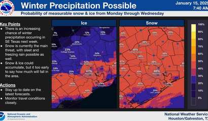
Posted Wed, Jan 15, 2025
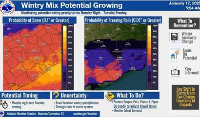
Winter weather may soon make a rare appearance in Southeast Texas. Forecasts indicate an increasing chance of measurable snow and ice from Monday through Wednesday,

Posted Sun, Jan 05, 2025
* WHAT...For the Freeze Warning, sub-freezing temperatures as low as 25 expected. For the Cold Weather Advisory, very cold wind chills as low as 14 expected.

Posted Sun, Jan 05, 2025
The National Weather Service has issued Tornado Watch 1 in effect until 6 PM CST this evening for the following areas In Texas this watch includes 7 counties

Posted Sun, Jan 05, 2025
WHAT...For the Freeze Warning, sub-freezing temperatures as low as 28 expected. For the Cold Weather Advisory, very cold wind chills as low as 15 expected. *

Posted Sat, Dec 28, 2024
SVRHGX The National Weather Service in League City has issued a * Severe Thunderstorm Warning for... Southwestern Montgomery County in southeastern Texas...

Posted Sat, Dec 28, 2024
Tornado Watch 719 remains valid until 5 PM CST this afternoon for the following areas In Texas this watch includes 4 counties In southeast Texas Liberty Montgomery

Posted Sat, Dec 28, 2024
TORHGX The National Weather Service in League City has issued a * Tornado Warning for... South central Montgomery County in southeastern Texas... North central Harris County in southeastern Texas... * Until 1215 PM CST. * At 1128 AM CST,

Posted Sat, Dec 28, 2024
The National Weather Service has issued Tornado Watch 719 in effect until 5 PM CST this afternoon for the following areas In Texas this watch includes 9 counties In southeast Texas Brazos

Posted Thu, Dec 26, 2024
Tornado Watch 715 remains valid until 7 PM CST this evening for the following areas In Texas this watch includes 9 counties In southeast Texas Brazoria Chambers

Posted Thu, Dec 26, 2024
At 201 PM CST, Doppler radar was tracking a strong thunderstorm near Montgomery, or 9 miles west of Willis, moving northeast at 45 mph. HAZARD

Posted Thu, Dec 26, 2024
The National Weather Service has issued Tornado Watch 715 in effect until 7 PM CST this evening for the following areas In Texas this watch includes 21 counties In southeast Texas

Posted Wed, Dec 25, 2024
The National Weather Service in League City has issued a * Severe Thunderstorm Warning for... Southeastern Montgomery County in southeastern Texas...

Posted Tue, Dec 24, 2024
The National Weather Service has issued Severe Thunderstorm Watch 713 until 6 AM CST Wednesday which replaces a portion of Severe Thunderstorm Watch 712.

Posted Tue, Dec 24, 2024
The National Weather Service in League City has issued a * Tornado Warning for... Southwestern Montgomery County in southeastern Texas.

Posted Tue, Dec 10, 2024
The National Weather Service (NWS) Houston/Galveston has issued a Freeze Watch for several counties in Southeast Texas, effective from late tonight through

Posted Mon, Oct 28, 2024
At long last, it appears that our two-month drought is coming to an end. While burn bands remain in effect, we can look forward to some skies that are greyer, streets that are slicker, and air and lawns that are wetter.

Posted Fri, Sep 13, 2024
In just one week from today, autumn will officially start. But it appears that summer didn’t get the memo, or else it’s decided to go out kicking and screaming. For the next week at least – and certainly this weekend – we’ll enjoy some decidedly...
Posted Mon, Sep 09, 2024
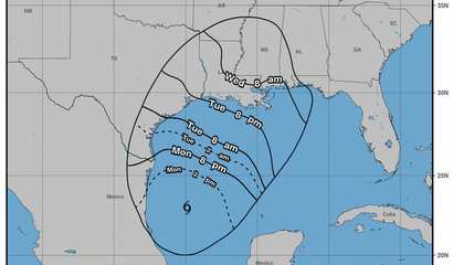
Once again, a storm is brewing in the Gulf. This time, however, it looks like we won't be going through the catastrophic, sweltering, Stone Age aftermath as we did with Beryl. For The Woodlands area, at least, it seems like Francine will be much...
Posted Fri, Sep 06, 2024
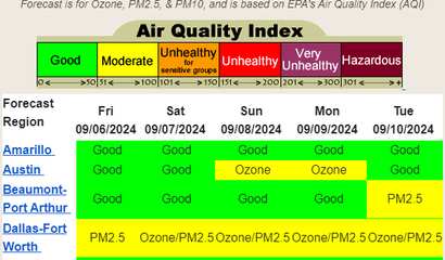
According to the Texas Commission on Environmental Quality, the air quality index forecast for this weekend looks good for The Woodlands area all weekend long!

Posted Tue, Sep 03, 2024
Rain may have put a damper on the Labor Day fireworks celebrations, but this week the precipitation should be light and late enough to not affect our lives too significantly.

Posted Fri, Aug 30, 2024
On the down side, a lot of steady rain is predicted for the long Labor Day weekend. On the plus side, that means the chances of accidental fires due to fireworks and outdoor cooking are at a bare minimum.

Posted Mon, Aug 26, 2024
It must’ve come as a shock to many of you to have to dodge some thunderstorms earlier today. Even more gasp-inducing is the fact that our high today will only get up to 89. Welcome to the lest legs of summer, at least for this week.
Posted Tue, Aug 20, 2024
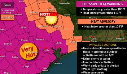
The Houston / Galveston office of the National Weather Service has announced a heat advisory extension, plus the addition of an excessive heat warning, both of which went into effect at 10 o’clock this morning will remain in effect until 10 p.m....

Posted Mon, Aug 12, 2024
You may be in for a bit of a shock this evening, as our indicators show a brief but raging thunderstorm hitting us this afternoon and evening, dumping more than a half-inch of rain in the area. But, mysteriously, it will leave as swiftly as it c...

Posted Fri, Aug 09, 2024
Summer is swinging away in this final weekend before most local school districts resume operations. For the most part, it will be sunny, hot, and breezy, hopefully making for some nice memories once the school bell rings.

Posted Mon, Aug 05, 2024
Be careful what you wish for; through the storms that have come and gone sporadically but consistently since April, and the freezes that preceded them, we’ve been hoping for a warm, dry 2024. Well, here it is.

Posted Fri, Aug 02, 2024
Temperance and moderation are the buzzwords this weekend as the weather decides to play nice for us in The Woodlands.

Posted Fri, Jul 26, 2024
If you were planning a trip to the beach or lake shore to get some suntanning in, this is the wrong weekend to book non-refundable tickets. All weekend long will be grey and gloomy, sometimes raging but always rainy. On the plus side, we won’t e...

Posted Tue, Jul 23, 2024
The National Weather Service in League City has issued a Flash Flood Warning for western Montgomery County until 530 PM CDT.

Posted Mon, Jul 22, 2024
Already the rumbling of thunder is resounding all over the area, and some of us might start suffering flashbacks to the recent storms. Unfortunately, there’s no escaping an entire week of thunderstorms and heavy rains.

Posted Thu, Jul 11, 2024
Ordinarily, the Woodlands Online Weather Team combines our weekend forecast with some accompanying events. We also post the predictions on Friday. However, this week, the aftermath of Hurricane Beryl and the ongoing issues of being powerless hav...
|
||||||||||||||||||||||||||||||||||||||||||
|

| Recent Articles | ||||||||||||||||||||||||||||||||||||||||
|
||||||||||||||||||||||||||||||||||||||||
| Articles by Month of Posting | ||||||||||||||||||||||||||||
|
||||||||||||||||||||||||||||