- Categories :
- More
Wednesday Hazardous Weather Outlook: Strong Storms and Heavy Rainfall Expected
By:
![]() Woodlands Online
| Published 09/23/2025
Woodlands Online
| Published 09/23/2025
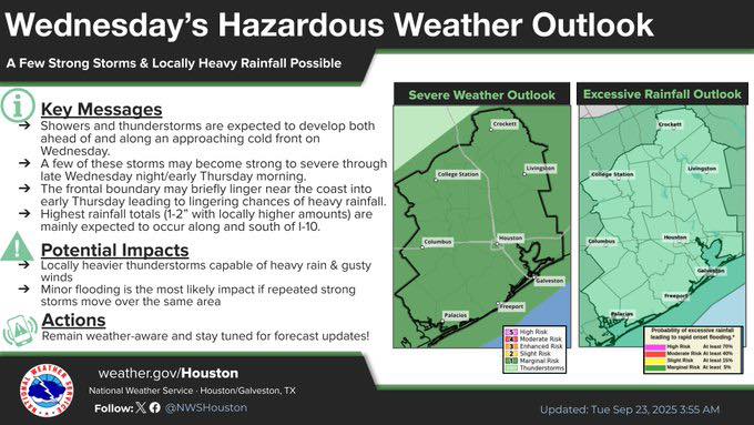
The National Weather Service has issued a hazardous weather outlook for Wednesday as a cold front moves through the region, increasing the chances of rain and the potential for severe weather and excessive rainfall.
Weather Overview:
Showers and thunderstorms are expected to develop ahead of and along the approaching cold front on Wednesday. A few of these storms may become strong to severe from late Wednesday through early Thursday morning. The frontal boundary may briefly linger near the coast into early Thursday, creating lingering chances of heavy rainfall.
Rainfall Expectations:
-
Highest totals (1 - 2 inches, with locally higher amounts) are expected along and south of I-10.
-
Locally heavier thunderstorms may bring gusty winds and heavy rain.
Potential Impacts:
-
Minor flooding is the most likely impact, especially if repeated strong storms pass over the same area.
-
Gusty winds may accompany stronger thunderstorms.
Safety and Preparedness:
Residents are urged to remain weather-aware, monitor forecasts closely, and never attempt to drive through high water. Stay updated for any changes in storm intensity or location.
Key Message:
A few strong storms and locally heavy rainfall are possible Wednesday through early Thursday. Please exercise caution and take necessary precautions.