- Categories :
- More
Categories

The Woodlands Information Station
Weather Category
Sort By:
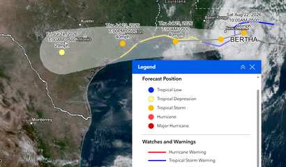
Posted Wed, Jul 22, 2026
The storm formerly known as Tropical Depression 2 and renamed Bertha is expected to hit the Houston / Woodlands area this Thursday evening around 7:00 p.m. as a tropical storm with winds up to 40 mph. At this time, the winds are predicted to be ...
Posted Wed, Jul 22, 2026
The National Weather Service has issued an Extreme Heat Warning for the entire Woodlands area.
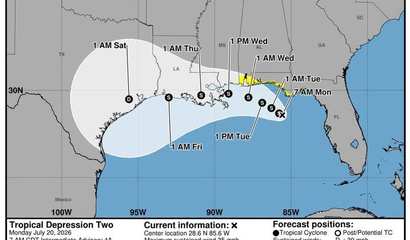
Posted Mon, Jul 20, 2026
At 700 AM CDT (1200 UTC), the center of Tropical Depression Two was located about 210 miles southeast of Mobile, Alabama.


Posted Wed, Jun 17, 2026
Conditions at Lake Conroe remain consistent, and outflows have remained unchanged since yesterday.

Posted Tue, Jun 16, 2026
SJRA has released this operational update as of today, June 16, 2026 at 11:30 a.m.

Posted Tue, Jun 16, 2026
Flash Flood Warning issued June 16 at 9:41AM CDT until June 16 at 12:00PM CDT by NWS Houston/Galveston TX
Posted Tue, Jun 16, 2026
Flooding caused by excessive rainfall continues to be possible. * WHERE...Portions of south central and southeast Texas, including the following areas, in south central Texas

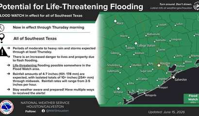
Posted Mon, Jun 15, 2026
POTENTIAL FOR LIFE THREATENING FLASH FLOODING. * WHAT...Flooding caused by excessive rainfall continues to be possible. *

Posted Sun, Jun 14, 2026
Flooding caused by excessive rainfall is possible. * WHERE...Portions of south central and southeast Texas, including the following areas, in south central Texas,

Posted Mon, Jun 01, 2026
At 707 PM CDT, Doppler radar was tracking a strong thunderstorm over Hooks Airport, or near Tomball. This thunderstorm was nearly stationary. HAZARD
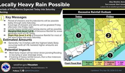
Posted Thu, Apr 30, 2026
Flooding caused by excessive rainfall continues to be possible. * WHERE...A portion of southeast Texas, including the following areas, Austin, Brazos,

Posted Sun, Mar 15, 2026
At 617 PM CDT, Doppler radar was tracking strong thunderstorms along a line extending from near Hudson to 6 miles southwest of Brenham.
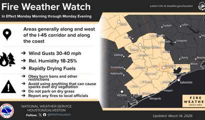
Posted Sun, Mar 15, 2026
FIRE WEATHER WATCH IN EFFECT FROM MONDAY MORNING THROUGH MONDAY EVENING FOR WIND AND LOW RELATIVE HUMIDITY FOR PORTIONS OF SOUTHEAST TEXAS,

Posted Wed, Mar 11, 2026

Posted Wed, Mar 11, 2026
Tornado Watch issued March 11 at 11:26AM CDT until March 11 at 6:00PM CDT by NWS Houston/Galveston TX
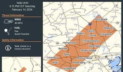
Posted Sat, Feb 14, 2026
At 509 PM CST, Doppler radar was tracking strong thunderstorms along a line extending from New Waverly to near Eagle Lake. Movement was east at around 60 mph

Posted Thu, Jan 29, 2026
For the Cold Weather Advisory, very cold wind chills between 11 and 25 expected. For the Freeze Watch, Hard Freeze with temperatures between 19 and 24 possible.

Posted Sun, Jan 25, 2026
Dangerously cold wind chills as low as 5 degrees well inland to around 15 degrees along the coast expected, with the lowest values Monday morning

Posted Sun, Jan 25, 2026
Significant icing expected. Total ice accumulations between one quarter and four tenths of an inch. Total sleet accumulations up to a half inch.

Posted Sat, Jan 24, 2026
Significant icing expected. Total ice accumulations between one quarter and four tenths of an inch. Total sleet accumulations up to a half inch. * WHERE...Brazos, Burleson, Grimes,

Posted Fri, Jan 23, 2026
Heavy mixed precipitation expected. Total snow and sleet accumulations up to one inch and ice accumulations between one tenth and one quarter of an inch.

Posted Fri, Jan 23, 2026
Heavy mixed precipitation possible. Total ice accumulations between one tenth and three tenths of an inch possible across the entire watch area, with the highest accumulations
Posted Thu, Jan 22, 2026
eavy mixed precipitation possible. Total ice accumulations between one tenth and three tenths of an inch possible across the entire watch area, with the highest accumulations in the Piney Woods and Brazos Valley.

Posted Wed, Jan 21, 2026
Dangerously cold wind chills as low as 5 to 15 possible, with the coldest values Sunday night into Monday morning. A hard freeze is also possible Saturday
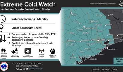
Posted Wed, Jan 21, 2026
WHAT...Dangerously cold wind chills as low as 5 to 15 possible, with the coldest values Sunday night into Monday morning. A hard freeze is also possible Saturday night and Sunday night
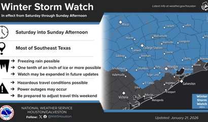
Posted Wed, Jan 21, 2026
Heavy mixed precipitation possible. Total ice accumulations between one tenth and three tenths of an inch possible across the entire watch area, with the highest accumulations in the Piney Woods and Brazos Valley.

Posted Tue, Dec 23, 2025
At least this isn’t the week to worry about frozen pipes. But it cannot be denied that this Christmas will be warmer than most and certainly more cloud-grey than snow-white.

Posted Sat, Dec 13, 2025
Sub-freezing temperatures between 27 and 32 degrees possible. * WHERE...A portion of southeast Texas. * WHEN...From late Sunday night through Monday morning. * IMPACTS

Posted Sun, Nov 30, 2025
At 1206 AM CST, Doppler radar was tracking strong thunderstorms along a line extending from near Batson to 6 miles southeast of Plum Grove to 6 miles southwest of Brenham.

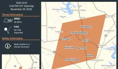
Posted Sat, Nov 29, 2025
At 527 PM CST, Doppler radar was tracking a cluster of strong thunderstorms near Spring, moving east at 35 mph. HAZARD...Wind gusts up to 40 mph and pea size hail.
Posted Sat, Nov 29, 2025
At 438 PM CST, Doppler radar was tracking a cluster of strong thunderstorms along a line extending from 6 miles northeast of Pinehurst to near Cypress.

Posted Sat, Nov 08, 2025
Red Flag Warning Issued Across Southeast Texas For Sunday... ...Fire Weather Watch Continues for Monday... The National Weather Service in Houston/Galveston
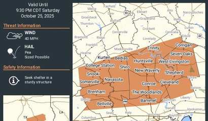
Posted Sat, Oct 25, 2025
At 828 PM CDT, Doppler radar was tracking strong thunderstorms along a line extending from near Alabama-Coushatta Reservation to 7 miles northeast of Montgomery

Posted Sat, Oct 25, 2025
The National Weather Service has issued Severe Thunderstorm Watch 631 in effect until 7 AM CDT this morning for the following areas In Texas this watch includes 13 counties

Posted Fri, Oct 24, 2025
Flooding caused by excessive rainfall is possible. * WHERE...A portion of southeast Texas, including the following areas, Austin, Bolivar Peninsula, Brazoria Islands, Brazos, Burleson,
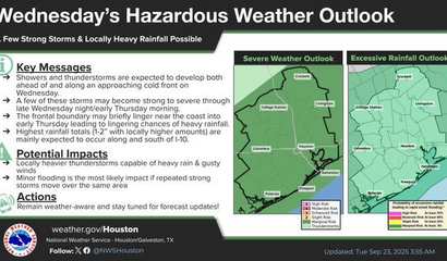
Posted Tue, Sep 23, 2025
The National Weather Service has issued a hazardous weather outlook for Wednesday as a cold front moves through the region,

Posted Wed, Aug 20, 2025
At 452 PM CDT, Doppler radar was tracking strong thunderstorms 9 miles west of Votaw, or 12 miles west of Thicket, moving southwest at 15 mph. HAZARD.
|
||||||||||||||||||||||||||||||||||||||||||
|

| Recent Articles | ||||||||||||||||||||||||||||||||||||||||
|
||||||||||||||||||||||||||||||||||||||||
| Articles by Month of Posting | ||||||||||||||||||||||||||
|
||||||||||||||||||||||||||